Plate tectonics, subduction zones, magma, volcanoes, such are the facts of life in The Ring of Fire. The Cascade Mountains that stretch from Canada to California are a manifestation of these forces of nature. On May 18, 1980, they contributed to the eruption of Mount St. Helens, a massive event that reduced the height of the mountain by 1300 feet and killed 57 people.
We moved to Portland, Oregon in June 1982. Portland is only about 50 miles from Mount St. Helens so events on the mountain were still very much in the news. No significant eruptions occurred when we lived there but it occasionally sent up small plumes of ash. Stores sold souvenirs made from the volcanic ash and the gutters of our apartment building were still laden with the light tan talcum-powder-like material.
We made our first trip to see the mountain in July 1982. The Mount St. Helens National Volcanic Monument had just been established and parts of the red zone had been reopened so we were able to drive in on a rather rough and dusty gravel road that provided access to much of the lower elevations. The remains of half-buried houses and torn up bridges were still visible along the route. The forest had been flattened, but weeds, grasses and wild flowers were growing in great profusion. The damage was incredible. The ability for life to regain a foothold was amazing. Meanwhile, Weyerhauser, the largest owner of timberland in the area, was quickly moving ahead with the salvaging of the downed timber.
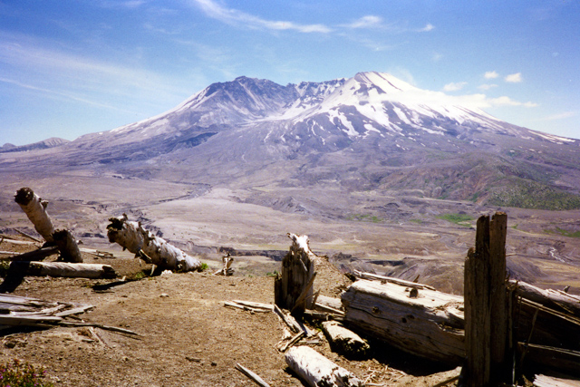
In 1985 we went back for another look. In the three years since our first visit, the Monument had been sanitized quite a bit. All the remains of the destroyed houses, bridges, and other structures in the area had been removed. The roads were smoother and official signs had been posted. A road had been opened up to Windy Ridge where we could look into the crater. The salvaging of the downed timber had been halted and many hillsides were still covered with downed trees dramatically showing the force and direction of the blast.
Spirit Lake had been the source of much concern since our previous visit. Because debris from the eruption had blocked the outlet, the water level continued to rise and threatened to cause severe floods if the debris dam broke. Pumps were set up to help stem the flow and by 1985 a tunnel had been constructed to allow excess water from Spirit Lake to safely drain away.
My father came out to visit us in 1987 so we took him to see Mount St. Helens. This time we drove completely around the mountain with a side trip to Windy Ridge. Some of the roads had been paved and, except for along the shoreline, the surface of Spirit Lake was almost completely free of floating logs. Although it still looked quite barren from a distance, closer examination showed that small trees were starting to take over in some locations. In some locations much of the formerly bare soil was now covered.
In June 1997 we took one last trip up to Mount St. Helens. Once again, relatives had come to visit and wanted to see this well-known landmark. By then the roads and parking lots were all nicely paved, a beautiful visitor center had opened, and signs informed visitors of the events that had happened 17 years earlier. It had become a nice tame member of the National Park System.
Although we lived in Portland for another 10 years, we never made it back to Mount St. Helens.